
|
- Distant View of the Mandan Village 1832. Plate 45. Catlin. The Manners, Customs and Condition of the North American Indians. London, 1892. Archives & Rare Books Department, University Libraries, University of Cincinnati.
|
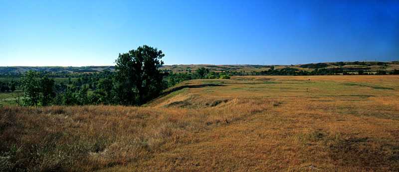
- Site of Fort Clark and the Mandan Village, near Stanton, North Dakota. photo by Alice M. Cornell 1997.
|
www.archives.uc.edu/exhibits/catlin/catweb_page14.html
Medicine Painter: George Catlin on the Upper Missouri, 1832. Their principal stop was at Fort Clark and the Mandan Villages where Catlin made some of his most significant ethnographic observations. The Mandan and neighboring Hidatsa were semi-agricultural people who raised vegetables including corn, beans and squash, as well as hunted buffalo. They were traders themselves, bartering their agricultural products for materials produced by the migratory tribes of the Northern Plains, as well as brokering the trade of other tribes.
|
|
Fort Clark
www.ndlewisandclark.com/sites/ft_clark.html
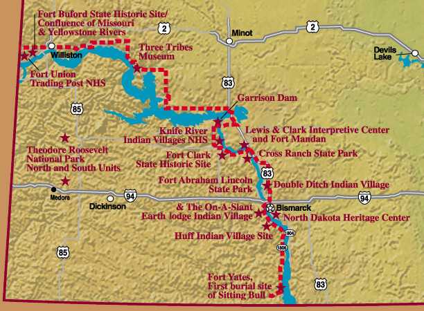
Fort Clark flourished with the fur trade, which was made possible by the discoveries of the Lewis and Clark Expedition. Notable memories of the fort include visits by artist-explorer George Catlin in 1833 and the German Prince Maximilian of Wied and his companion, the Swiss artist Karl Bodmer, the next year. Fort Clark also holds a story of incredible sadness. The steamboat "St. Peters" brought the small pox virus to the fort in 1837, and the resulting epidemic reduced the Mandan nation from between 1,600 and 2,000 people to less than 200 survivors. A stone shelter, built by men from the Works Projects Administration in 1939, marks the fort today. The grassy area is rough, pocked with the circular depression of earth lodges and marked by the foundations of buildings used by the fur traders. It sits on a low bluff on the west side of the Missouri River, looking over cottonwood-filled river bottoms. Named in honor of William Clark, it's one of three major forts built on the upper Missouri River after the Columbia and American Fur companies consolidated in 1827. The other two strategic forts were Fort Union, 150 miles up river, and Fort Pierre, near present day Pierre, South Dakota. Although Lewis and Clark wrote extensively about the Mandan and Hidatsa people, there was more to be learned. It was at Fort Clark that Catlin and Maximilian recorded their observations about these two important Indian nations. Lumber for the fort was prepared in the fall of 1830 by James Kipp of the American Fur Company, and the following spring the walls of the fort were erected. David D. Mitchell was the first man in charge of the fort. Kipp took over in 1833 and he was succeeded by Francis A. Chardon. It was Chardon who recorded in his journal the suffering and death of many of the Mandan people. At first he listed the names of all the dead, then he only recorded the names of the men who died. The women and children perished too fast for him to keep track of their names. Suicide and murder-suicide were common. Catlin wrote: "They destroyed themselves with their knives, with their guns, and by dashing their brains out by leaping headforemost from a 30-foot ledge of rocks in front of their village." Chardon reports that half of the Hidatsa and Arikara nation were dead and seven-eighths of the Mandan. The Mandan village of 150 lodges sat on the bluff adjacent to Fort Clark, which fell away in a 40 to 60 foot drop on two sides, making it necessary to only fortify the village on the remaining two sides. The fort, 120 x 157 feet, was abandoned by 1863. Fort Clark is 55 miles north of Bismarck and 14 miles west of Washburn, equidistant between the North Dakota Lewis and Clark Interpretive Center and the Knife River Indian Villages Historical Site. A self-guided tour, an interpretive presentation and video about the life of the Mandan Indians are available at the site.
www.state.nd.us/hist/sitelist.htm#clark
25. FORT CLARK STATE HISTORIC SITE -- Located seven and one-half miles southeast of Stanton, Fort Clark was built in 1830-1831 by the American Fur Company to serve a Mandan Indian earthlodge village built on the site in 1822. A second fort, Primeau's Post, was built on the site in the early 1850s and operated in competition with Fort Clark for much of that decade. The site contains foundations of both fort structures, the remains of the earthlodge village, and a large native burial ground. The site is open from May 16 through September 15, 8 am to 5 pm (CDT) Closed Tuesday and Wednesday. Self-guided visit, limited access. No facilities. No site admission fee. Information: State Historical Society of North Dakota, 612 E. Boulevard Ave., Bismarck ND 58505 or (701) 328-2666 or (701) 794-8832 or cjohnson@state.nd.us. For more information on the region call the Bismarck-Mandan CVB: 1-800-767-3555. 27. Fort Mandan Overlook State Historic Site -- Located eleven and one-half miles west of Washburn, this site overlooks the area where Lewis and Clark established their headquarters for the winter of 1804-1805. The original Fort Mandan was a triangular fort which provided shelter, protection, and a place of cultural interchange between the explorers and the area's Indian inhabitants. There are two markers on the site. [Paul Primeau, Charles' father, was on the Lewis & Clark expedition: Primeau, Pvt. Paul: Married Pelagie BISSONET, sons Joseph, Emilien & Charles; Joseph killed by Indians 1 Feb 1863; Charles had trading post at Ft. Clark 1845-46.] www.state.nd.us/hist/ndhist.htm#fur trade With several notable exceptions, contact between the Native peoples and American traders, explorers, and military personnel in the Northern Plains remained peaceful during the early 19th Century. Indians became instrumental in the fur trade; major trading posts at Fort Union and Fort Clark, and others of lesser significance, catered mainly to Native trappers and hunters. In exchange for their meat and furs, the Indians received guns, metal tools, cloth and beads, and other trade goods. This exchange forever altered Indian cultures, and it often brought dangers; in 1837, for example, smallpox virtually wiped out the Mandan people at Fort Clark.
Fort Clark
... Downstream from Garrison Dam along the west bank of the Missouri River, the Knife River Indian Village National Historic Site (daily 8 am-6 pm in summer, daily 8 am-4:30 pm in winter; free) is one of North Dakota's most fascinating historic places, and the only federally maintained site devoted to preservation of the Plains tribes' cultures. Standing above the Missouri floodplain, on the site of what was the largest and most sophisticated village of the interrelated Hidatsa, Mandan, and Arikara tribes, the park protects the remains of dozens of terraced fields, fortifications, and earthlodges, remnants of a culture that lived here for thousands of years before being devastated by disease within a few short decades of European contact. Highlight of the park is an earthlodge, recently reconstructed using traditional materials, which gives a vivid sense of day-to-day Great Plains life. Measuring over 50 feet across, and 12 feet high at its central smoke hole, the earthlodge looks exactly as it would have when the likes of George Catlin and Karl Bodmer were welcomed by the villagers during the 1830s. Just north of the earthlodge spread circular depressions in the soil - which is all that remains of the Hidatsa community where in 1804 the Lewis and Clark Corps of Discovery was joined by the French fur trapper Charbonneau and his wife Sacagawea. The modern visitor center, well signed off Hwy-200 at the south edge of the park, has high-quality reproductions of the drawings and paintings that Catlin, Bodmer, and others made of the Knife River Indian Villages, along with archaeological and anthropological summaries that help to bring to life these intriguing Native American peoples.
... Today the tranquil site, approached on a narrow gravel-and-dirt road, is devoid of anything - a somber, quiet, unretouched piece of history stretching out on a grassy, flat-topped bluff overlooking the Missouri River. A walking trail has markers designating the locations of eight original buildings; depressions from an earthlodge village are still apparent.
Fort Mandan The actual site of Lewis and Clark's encampment, some 10 miles upstream across the river from the site of Fort Clark, was long ago washed away by the ever-shifting Missouri River, but the full-scale, historically accurate replica fort, built in 1969 by local history buffs, is open all day and night with no admission charge, and gives a strong sense of the deprivations and discomforts suffered by the Corps of Discovery on their two-year expedition across the continent. The fort also has a basic visitor center (1-5 pm; free) and an adjacent park with outstanding though bare-bones camping ($5) right along the restless Missouri River. It's a great place to play Tom Sawyer, and on summer afternoons you'll see barefoot kids, shirtless in overalls, fishing and mucking along the banks. Heading south along Hwy-1806 from Mandan along the west bank of the Missouri River, the first place you'll reach is sprawling Fort Abraham Lincoln State Park (daily 8 am-dusk; $3), which was originally established by the Northwest Company as a fur-trading post in 1780. It eventually fell into the hands of the U.S. Army, which in 1872 changed the fort's name to the present one. Soon afterwards, General Custer arrived to take over the reins of command, and in 1876 the fort was placed squarely on the map and in the national press as the departure point for the doomed general and his 250 men, who met their demise at Little Big Horn. Abandoned in 1891, the fort was dismantled by settlers who salvaged the wood and bricks to build their own homes, and most everything here today is a reconstruction.
find: Chardon, Francis A. , Chardon's Journal at Fort Clark, 1834-1839; Descriptive of Life on the Upper Missouri, of a Fur Trader's Experiences Among the Mandans, Gros Ventres, and Their Neighbors; of the Ravages of the Small Pox Epidemic of 1837: 1970, Books for Libraries Press.
www.curtis-collection.com/tribe%20data/lakota.html
www.curtis-collection.com/tribe%20data/bsketches3.html
www.curtis-collection.com/tribe%20data/bsketches4.html
www.curtis-collection.com/tribe%20data/bsketches5.html |